
Our services are used by 700+ companies
We have installed over 9,000 devices
Special solutions based on the clients’ needs
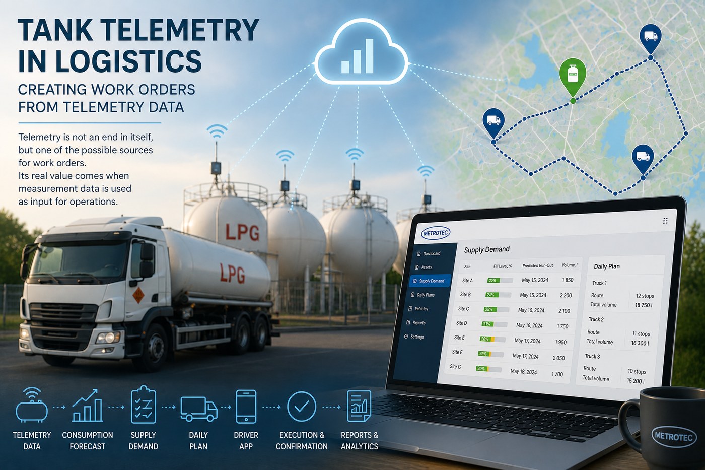
Telemetry is not an objective in itself—it is one of the possible sources of work orders. The real value of measurement data is realized when it is used as input for operational planning.
Work orders are created in different ways depending on the company. In some cases, they are entered manually by customer service personnel, while in others they are received directly from the company’s ERP system. There are also business processes where work requirements are generated automatically based on measurement data collected from field devices.
A typical example is LPG distribution logistics. Tank fill levels are continuously monitored using telemetry, and the collected data is used to estimate when each tank will require its next refill. This creates a list of delivery requirements that serves as the basis for generating work orders for the following day or several days ahead.
The LevelSense monitoring system continuously collects tank level data and stores its historical changes. Based on this history, the application calculates the average consumption of each location and predicts when the remaining product in the tank will reach a predefined critical level.
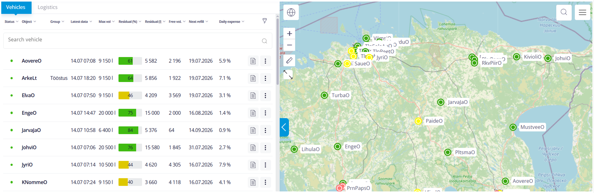
This approach enables deliveries to be planned several days in advance. Planning is therefore no longer based solely on the current fill level, but on an accurate prediction of when replenishment will actually become necessary.
The generated delivery requirement is not final. Before daily delivery schedules are created, the list can be reviewed and adjusted according to the actual operational situation. For example, servicing a particular customer may be postponed or temporarily removed from the schedule. Different products—such as propane, butane, and their mixtures—can also be handled separately to prevent incompatible deliveries from being combined.
Once the delivery requirement has been confirmed by defining the delivery date and the locations to be serviced, the available transport resources are assigned to the planning program.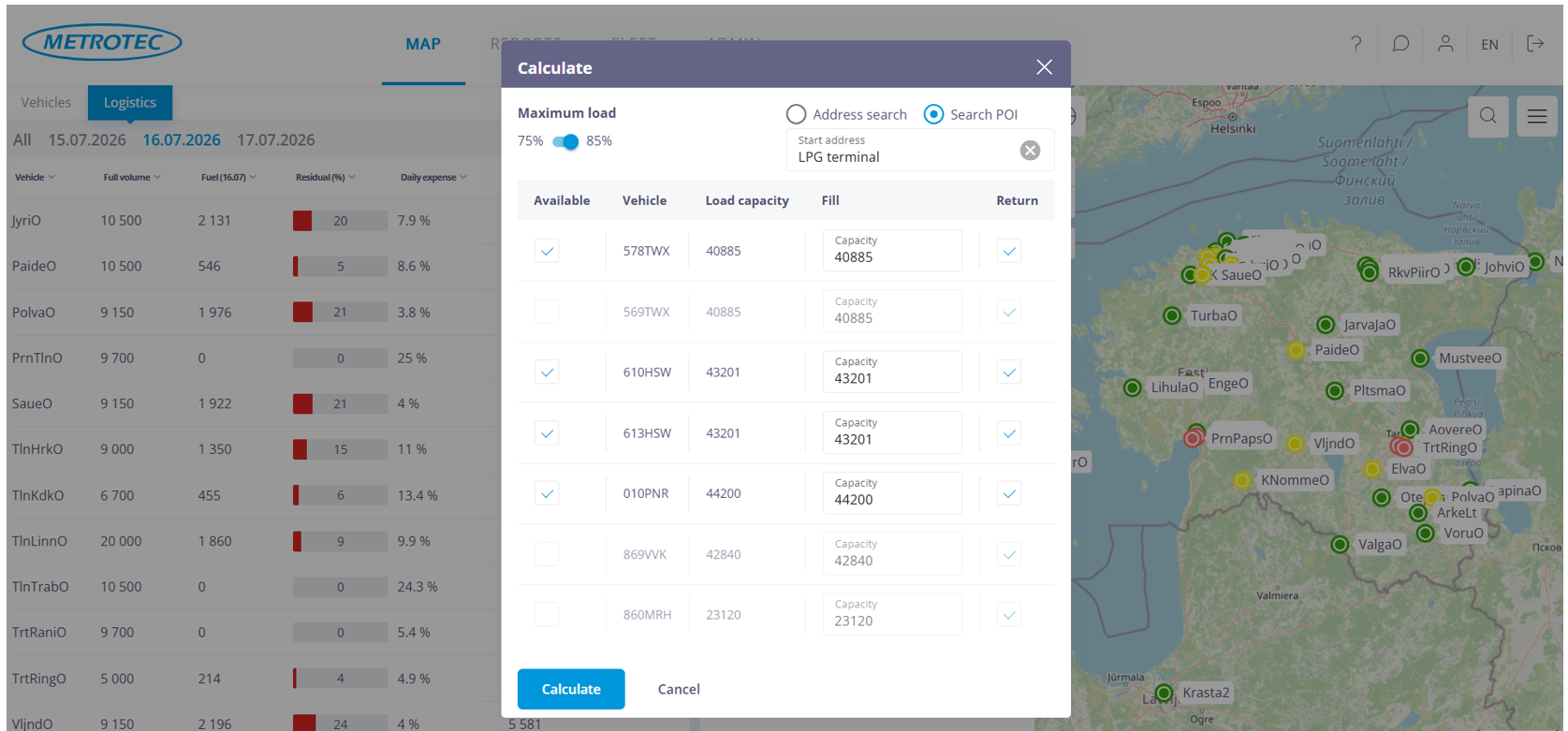
The system takes into account available vehicles, vehicle capacities, loading terminals, drivers’ working time restrictions, and other operational constraints that affect route planning.
Based on these parameters, the system generates a proposal for distributing deliveries between the available vehicles. Automatically generated routes are intended to support the logistics planner rather than replace their decisions.
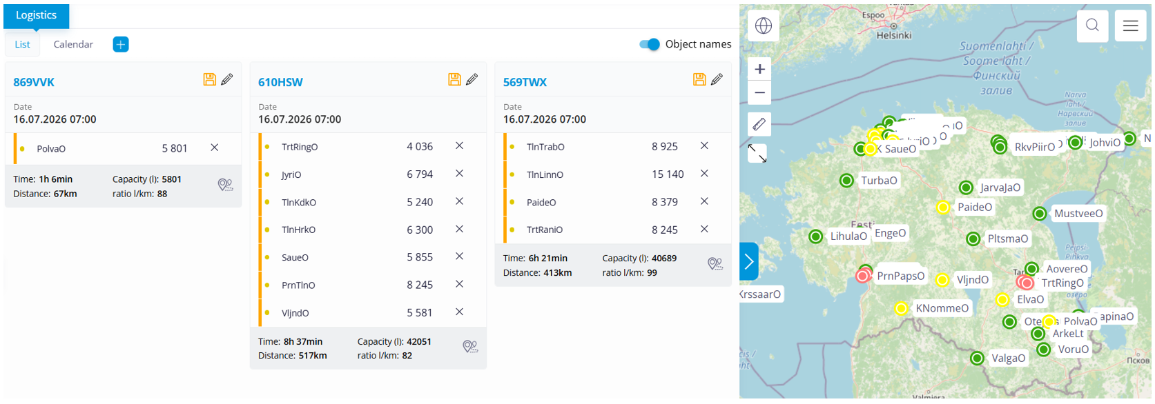
In practice, planners often make adjustments before releasing work orders. A delivery may be reassigned to another vehicle, several deliveries may be combined, or some may be postponed until the following day. Such modifications are a normal part of the planning process, and the system allows them to be made before the schedule is finalized.
The daily planning view allows the planner to verify that the proposed routes meet operational expectations.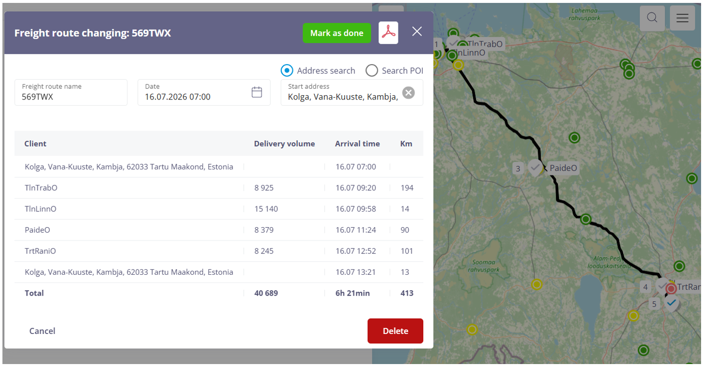 Routes, stop sequences, working hours, and delivery allocations can all be reviewed before work orders are released. If necessary, the delivery plan can be modified and recalculated.
This approach combines automated optimization with the practical experience of the logistics planner.
Creating work orders is only one step in the overall workflow.
Once the daily schedule has been approved, work orders are automatically transferred to the driver’s mobile application, where the driver can see the assigned tasks, the execution sequence, location details, and all information required to complete the work. During execution, the driver can update the work status, add notes, attach photographs or other evidence, and confirm task completion. Where required, a digital handover process can be used to document the completed work directly at the customer’s location.
All information collected during the delivery process is stored in a single system. It is later used for process monitoring, reporting, quality assurance, and integration with other business information systems.
Telemetry marks the beginning of the workflow. The same work order continues through the entire operational process—from automatic creation to execution, completion, and performance analysis.
The same workflow is suitable wherever work requirements are generated automatically from collected data. Sama töövoog sobib aga kõikjale, kus töövajadus tekib automaatselt kogutud andmete põhjal. The input may come from maintenance schedules, production equipment status, inventory levels, or any other information system.
Regardless of the source, the role of the Work Order module remains the same: to collect planning data, generate work orders automatically, and provide users with the opportunity to review and adjust them before they are released for execution.
EX-certified method
Need a reliable and solid solution that can be depended on 24/7 to measure the level of fluids in high-risk environments classified as ‘flammable’ and ‘explosive’?
We offer a precise, fully automated, maintenance-free solution that comes with no human factor involved. The solution is intended for measuring the level of diesel, gasoline, fuel oil or liquefied gas, but has also been used for non-hazardous fluids such as AdBlue and water.

When you use a fluid consumption meter to measure the quantity consumed, the process is inescapably tainted by a systemic error that cannot be compensated for. Due to wear of the metering device itself, the error increases indeterminately. This results in a cumulative difference between the measured and the actual quantity and finally leads to a situation in which you are faced with an empty tank which according to continuous measurements should still contain a usable volume of fluid. The individuals involved are puzzled – there is nobody to blame. It is not to be excluded that such situations will be taken advantage of. To avoid unpleasant surprises of this type, you should install a system for parallel measurement of volume by a fluid level sensor.
Principal advantages
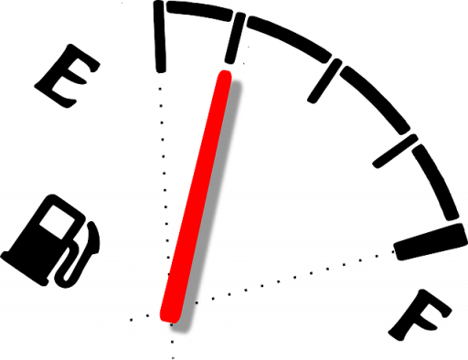
First, you will always have sufficiently precise information concerning your remaining fluid stock – without craning your neck to steal a peek into your tank in cold and wet weather and without getting your hands and clothes dirty.
Second, the system is aware of your consumption rate and can alert you when the next fill-up is required.
Third, the system helps manage your overall fill-up logistics.
Fourth, the system comes with various analytics features based on periodic registration of fluid balance.
Easy to deploy
Level measurement is performed by a pressure sensor which is submerged in the tank. To insert the sensor, you need an opening with a diameter of 1.25’’ (3.2 cm). If none is available, the principal difficulty boils down to drilling the required opening. Since the environment in the tank is high-risk, you can’t fasten drilling equipment to the tank. The amount of labour required to unmount and remount the lid differs by type of tank and could take anywhere from 30 minutes to several hours. As for the rest, a bare minimum of installation work is needed. The device, powered by a single Li-ion cell, is weatherproof and does not require any cabling. You don’t have to worry about the power supply – the system is extremely low-consumption and the cell should last 10 years. In principle, the solution can be installed in any tank.
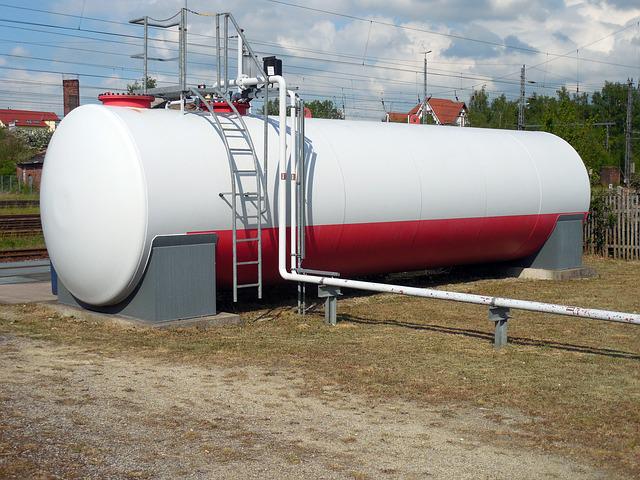
Pressure sensors are rated to operate at depths of up to 3 or 5 m. To achieve precise measurements, you need a tank graduation table (height of the head of liquid by 10cm intervals and the corresponding volume).
In the case of liquefied gas, things are even more straightforward. Gas level is measured on a contactless basis by a Hall sensor and you can use the installation socket of an existing sensor. The entire procedure and commissioning sequence can be completed in 20 minutes.
Fill-up logistics arrangements
Depending on actual balance (over one half, less than one half and less than one third), tank locations are shown on the map in different colours. Essentially, you can take in the balance of different tanks at a single glance and get your bearings for making logistics arrangements.
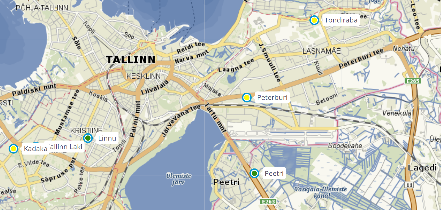
A click on the map displays detailed information concerning the selected tank (current balance, capacity, temperature, power supply voltage). Based on last day’s consumption, the system estimates the time for the next fill-up.
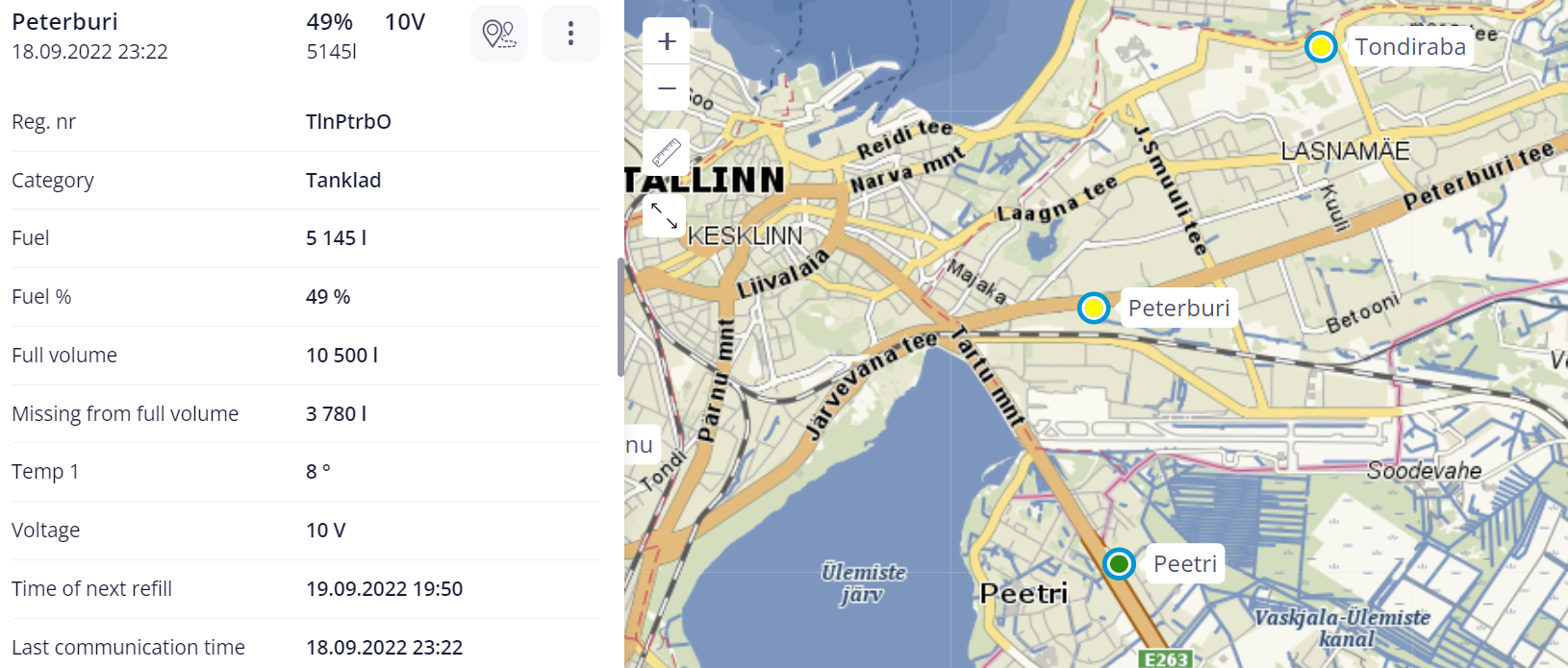
Based on periodically registered measurement values, the system offers various analytics. Users can compile comparative reports and sort data by quantities consumed or supplied. Reports will show daily consumption including initial and final balance. You can set reporting periods according to your requirements. Tanks can be assigned to user-defined groups. There is a data history feature that displays the balance of fluid in the tank at a specific point in time. Another feature helps the user assess whether fill-up logistics during a certain period has been efficient.
Handy additional features
The system is compatible with the filling station management software Cloudics and can be configured to display fluid balances in that environment, allowing regular Cloudics users to have access to the data through their usual interface.
The existence of an API. The customer can integrate the Metrotec app with their information system to automatically import Metrotec-provided data.
The customer can make a part of their tanks visible to its clients, or use Metrotec reporting forms to send data to clients.
References
The solution is in use and has met with approval in the filling stations of Alexela, Olerex and Tartu Terminal. The devices have been installed in surface as well as subsurface tanks holding LPG, diesel and gasoline.
A work order citing a specific location and guidance is the first thing with any job. Only after it is in place can we start considering job performance and operational speed. Metrotec’s job management application links up the driver, the logistician, the customer and, where this is needed, also the accounting software. Booked and completed jobs are detailed in a report that makes it easy to invoice deliveries of goods and supplies of services.
The driver’s view of the application shows the tasks to be performed together with specific locations, routing and instructions required to complete them. To acknowledge the delivery/supply, the driver asks the customer to sign for it electronically. Should the driver encounter any obstacle which makes it impossible to deliver the goods or provide the service, it is also possible for them to add their own photos or comments.
Where this is needed, the logistician can set a specific access route, minimising the time that it takes to find a destination. Since there are different types of customers, there are also several versions of the application with different approaches to job setting, the number of interim waypoints and the resulting report of job completion.
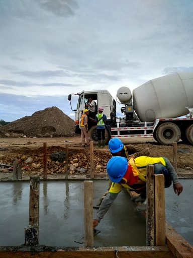
A concrete mixing plant operator has its own register of orders, based on which it sells and invoices the concrete that it mixes, transports and pumps. The problem with the system is the number of paper documents involved and the need for manual input of the duration of various operations. To be competitive, an operator needs to precisely account the time spent on transport, pumping and wash-up. The process may also involve subcontractors who must be paid for transport and pumping services. Operations must be speedy, precise and transparent – otherwise time-consuming disputes may arise and mistrust will stifle cooperation. Checks are necessary yet time-consuming and create a lot of nuisance for both parties.
Customers also want to have online access to their order history and order delivery status and are interested in having transparent supply chain processes.
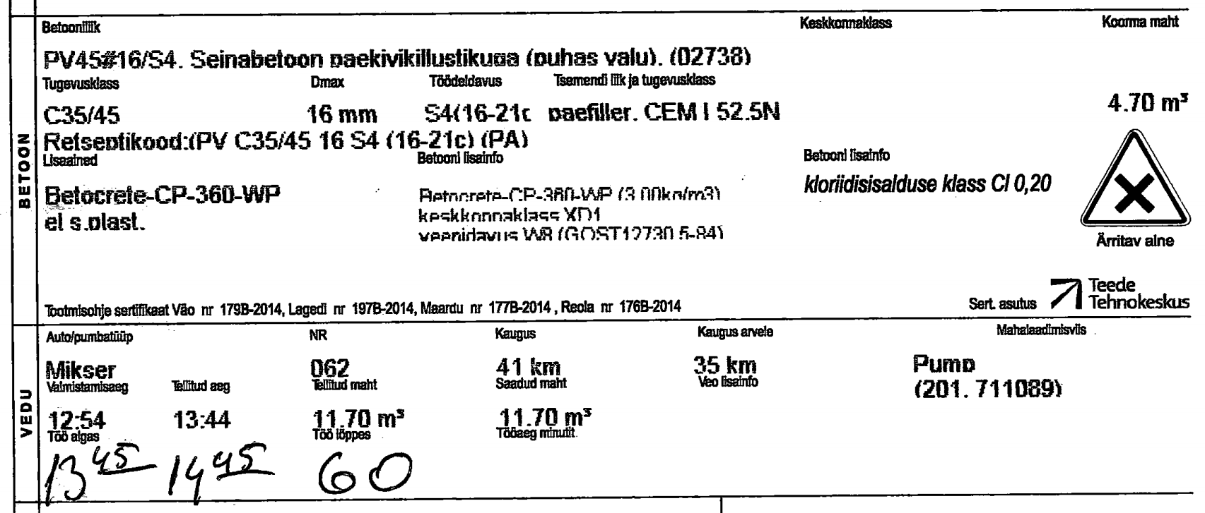
Orders for concrete transport and pumping are automatically transmitted to Metrotec. Metrotec software generates a tasking for the driver. Location, route and any required additional information is displayed on driver’s tablet screen. Where needed, the driver can add their own comments concerning pumping or other delivery method or any additives they have mixed into the batch. The application also allows the driver to have the customer sign for the delivery on-screen.
There is no more need for the driver to make handwritten notes of arrival and departure times – this will be taken care of by the application. Among other functions, these times are automatically forwarded to the operator’s own system of orders. Completed jobs are reflected in a report that shows specific pumping/delivery durations.
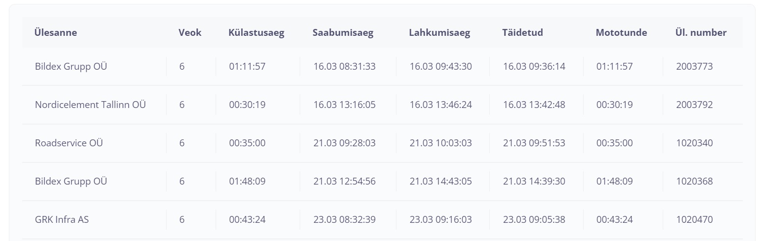
Mostly, managers are aware of the number of operating hours a piece of equipment has clocked up, and of how many more it would be capable of before breaking down. Maintenance and repairs, however, tend to take place helter-skelter – their organisation is chaotic and their documentation haphazard. Maintenance logs are filled out in handwriting, some of it illegible, with no photos or digital files attached. Even where there is an Excel table, it is inevitably kept – and can be understood – by a single employee who is not available when they are needed. Often, maintenance and repairs appointments arrive out of the blue for the people involved, resulting in unnecessary haste, lost hours, the need to reorganise jobs and sometimes also contractual penalties.

The solution to the problem is an electronic maintenance diary. This is a tool that permits booking maintenance and repairs slots and alerts users to the need to do so. Equipment particulars are highlighted automatically when a maintenance appointment or a scheduled maintenance date is coming up, giving managers advance notice to plan for the appointment and providing a reminder of approaching or overdue maintenance.
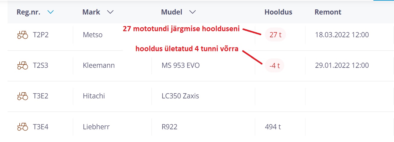
The diary makes current mileage or hour meter readings accessible to everybody. The reading at which equipment should be maintained is calculated by the application. The need to carry out maintenance should be known to all parties involved – the equipment manager, team leader, machine operator and maintenance provider. Equipment needs to be cleaned and prepped for maintenance. Spare parts have to be ordered, a transport lorry arranged for heavy equipment, the operator given a day off.
Maintenance dates are proposed by the application based on preset maintenance intervals, taking into account the number of operating hours the equipment has accumulated. Certain users have access to application data, while information on the machine is accessible to all parties involved. Similarly, dates set by the equipment manager for specific repairs or maintenance are visible to everybody. There is no fuss, yet repairs and maintenance proceed smoothly and everybody’s up to date with what’s going on.
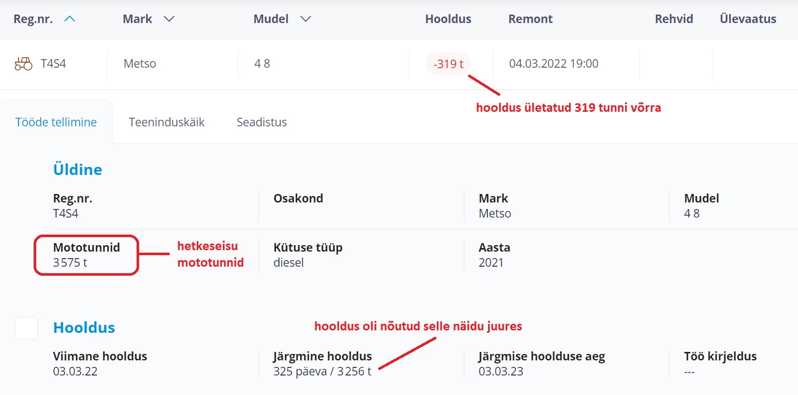
Want to be a good equipment housekeeper? The first and easiest thing to achieve this is setting up an inventory of how your equipment is maintained.
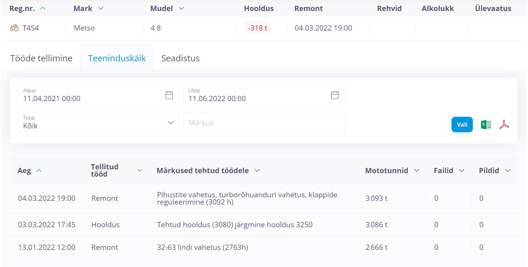
Maintenance operations are recorded and documented with all photos, invoices and offers logged systematically and accessible in the same location. Easy to search and quickly found. Whenever you need it, you can see at what mileage or hour count a repair or maintenance was carried out. A definite bonus also when you need to sell the machine.
The availability of up-to-date and precise information is a prerequisite for good management. Old- school types find that to determine the location of a person or a vehicle, you can simply call them. That is, of course, correct. Yet what about situations when the line you are calling is occupied or the phone is switched off or outside network coverage? What if the person you are calling cannot answer the call for valid reasons, or if they answer your call and bury you under a stream of excuses? Feels uncomfortably familiar, doesn’t it?
With the passage of time, the constant need for information becomes increasingly acute. Incessantly calling someone to check on their activities is extremely tiresome for both parties and may even be perceived as harassment. Instead, consider GPS tracking of vehicles – easy and convenient, these solutions spare your time and your nerves. A GPS tracker installed on the vehicle always knows the precise location of the vehicle, is always turned on and regularly communicates information to the database of the tracking system. The information you need is at your fingertips exactly when you need it and you never have to depend on anyone else.
Just like finance managers obtain the information they rely on to make the company’s financial decisions from the company’s accounting department, the dispatchers or fleet managers constantly tap into the GPS datastream to receive fresh location data for better coordination of the vehicles’ operation.
Already the awareness of being remotely monitored has a disciplining effect and shapes employees’ attitudes towards time use during working hours. This, in turn, the chance of subsequent arguments between the driver and the employer, decreases the number of unladen journeys and increases the transparency of the entire work process.
The purpose of the GPS tracking system is not to expose slackers – rather, it serves to reveal errors and oversights resulting from ignorance, insufficient instruction or planning.
With location and journey history, drivers’ work can be arranged more effectively from the perspective of both the employer and employee. Appropriate and effective work arrangements improve the company’s work atmosphere, increase the employees’ trust in the management and boost productivity.
Data history provides an unbiased record of events and can confirm, for instance, whether the agreed destination was or was not reached at the agreed time, or whether the vehicle did or did not perform a certain journey or was or was not at a certain location. By replaying data history, it is possible to assess the efficiency of the vehicles’ journeys and identify areas where significant improvements could be achieved in future.
GPS tracking puts an end to constant bothersome inquiries to drivers regarding their current whereabouts. It means less stress and worry for one party and the disappearance of perpetual interference for the other, being of considerable benefit to both and, at the same, allowing you to keep a tab on the work process.
Earlier experience with GPS tracking certainly corroborates the claim that GPS tracking saves the company at least 10 minutes every day. If we set the cost of an hour at 25 euros, it adds up to about 100 euros per month.
Considering that the basic GPS starter pack costs 77 euros and the monthly service fee amounts to six euros, the GPS tracking system will recoup its cost with the first month of use.
Installation procedures will be determined by your device. The simplest GPS device looks like a slightly oversize matchbox and is designed to be plugged into your vehicle’s on-board diagnostics (OBD) port. Its installation is like connecting an electrical plug to a wall socket – an operation that anyone can perform without outside assistance.
After installation, having concluded a service agreement with the provider of the service, you can start using the system immediately.
Using data received from your GPS tracking unit, the system compiles reports regarding your vehicle’s travel speed, mileage, driving and stationary time.
Another useful feature is geofencing — you can define areas of interest on the map and set the system to compile reports on the vehicle’s visits to those areas. Fitted with appropriate sensors, GPS devices can register temperature, fuel level in the tank, engine RPM, the status of side hatches, as well as the operational status of lifting equipment, winch or any other important additional system of the vehicle. Together with location data, such units will transmit to the server the readings of all sensors connected to them.
The more important custom features of our solutions include reservation of shared-use vehicles, driver identification, keeping track of employees’ working hours outside the office, remote downloading of digital tachograph data, two-way communication with the drivers, automatic transfer of GPS tracking data and derived data products to the client’s information system, and a host of other useful options. The wider the range of features used, the greater the overall benefit to the client’s business.
The logging of operating hours provides the basis for operation and maintenance of heavy equipment. The operating effectiveness and overall condition of a machine is assessed on the basis of the operating hours it has accumulated. Its average fuel consumption is expressed in litres per operating hour.
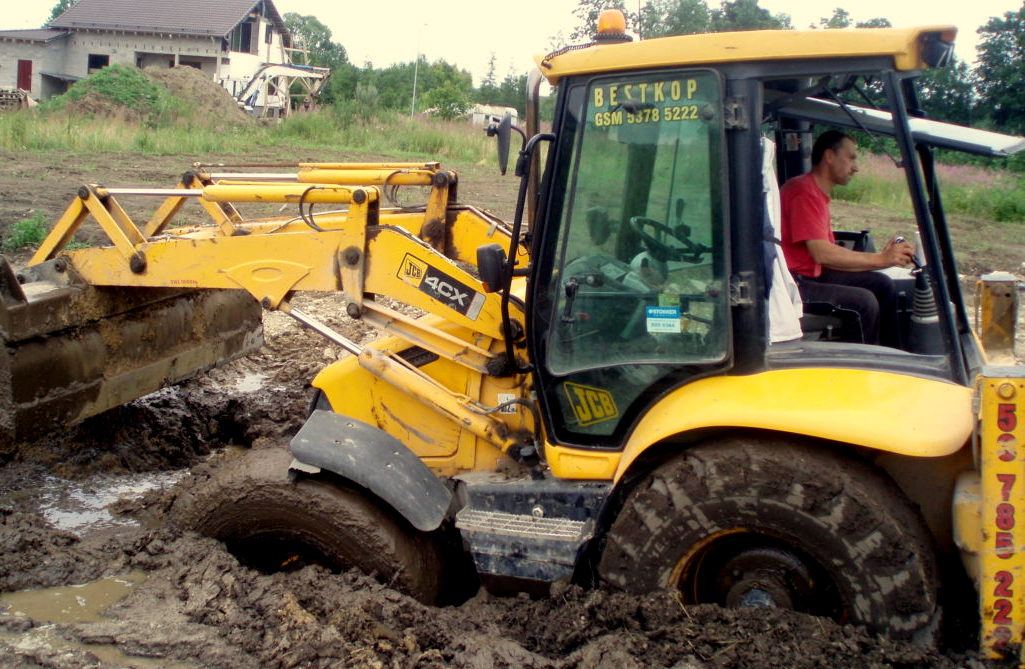
However, how do you keep track of operating hours, how frequently are the corresponding readings transmitted to the fleet manager and what happens to these data afterwards? Can you really say that you know the work process of your machine so well that you are able to reproduce, if necessary, any time point or time period from its operating history? This could be important since, knowing the details, you will be able to understand historical operating situations correctly and to resolve disputes effectively.
The mere fact that N operating hours were accumulated during the past month does not tell us anything about the effectiveness of those hours. Yet this is what we need to know in order to improve cost efficiency.
The solution is GPS tracking! The GPS tracker monitors the operating status of the machine, always knows the current operating hour count and, what’s even more important, can tell you whether the engine is idling or runs with a heavy load.
With such information, you are able to settle arguments and prevent problems before they occur. At the same time, accurate up-to-date reports are at your disposal any time, just when you need them most. GPS tracking simplifies the management of your equipment, makes it an orderly affair and saves you time.
It is no news to anybody that competition is stiff in every area of business, making it difficult to earn a profit. In a situation where revenue can grow only so slowly, one should look for more effective ways to keep the expenses in check. In the case of heavy equipment, the largest expense items are fuel costs and depreciation due to wear and tear from operation. GPS tracking effectively keeps an eye on every litre of fuel consumed and every minute spent working.
“On Metrotec website, I can see exactly how many hours have been spent idling and how much time was spent productively. The GPS device also allows me to pinpoint the exact location of all machines at a given moment. In this way, I get a very clear picture of what is going on at the site,” explains the owner of a rental backhoe company about a particular GPS tracking solution that has benefited his business.
Through the monitoring of engine RPM, it is possible to understand what was done during the working hours and whether it served a useful purpose. It is no longer possible for a driver to leave the vehicle idling while attending to some personal business.
The idle time report clearly shows the estimated amount of fuel wasted and the reduction of the time left before the next scheduled maintenance. When equipment is acquired for the fleet, one also normally considers its reselling options. It is important to note here that a typical 20% idle time automatically reduces the future selling price. By GPS tracking, idle time can be kept under control and its negative effect on secondary market price reduced.
Reports are unavoidably necessary. They are required for the calculation of employees’ working time and salaries and for the company’s cost accounting. Have you ever thought about the tedium of collecting the necessary data each month, not to speak of the time required for manual data entry? And what if an error should slip in during the entry?! The GPS tracking system records the beginning and end of operating cycles accurately to the second and never makes a mistake adding or subtracting numbers. You will never again have to waste a minute on this drudgery or inflict the unpleasant duty on anyone else. Current reports are always at your disposal, just when you need them most.
Isn’t it familiar―a client wants to know exactly how much a certain job is going to cost, while it is difficult to accurately estimate the amount of work involved. GPS tracking measures working time faultlessly and makes the process transparent to the client as well if desired. Accuracy is a sign of professionalism on the part of the service provider. Your clients will appreciate this and be more accommodating if you need them to be flexible. It is always possible to check data history to establish when something happened and determine what exactly happened, was it then the beginning or end of work or an idle period, or something else entirely. This will provide for quick and effective settlement of any arguments.
Regular maintenance is key to the long service life of any construction vehicle. Experience has shown that ignoring the regular maintenance schedule tends to lead to hefty repair bills down the road and even to premature termination of the manufacturer’s warranty. If your vehicles miss their scheduled maintenance, you may later be facing thousands of euros of unproductive costs.
Naturally, the maintenance schedule can be created and stored in Excel and many heavy equipment owners indeed do so. However, everyone knows that manual data entry always runs the risk of errors, not to speak of the time-consuming and dull nature of this activity, and missed maintenance may be the consequence.
In this regard, the GPS tracking system functions like an alarm clock, set to alert the persons in charge of an upcoming maintenance obligation. The system always keeps track, serves you without fail 24/7 and never forgets anything or anybody.
Just by tracking idle time and reducing it by 10%, we can gain a 10% increase in the residual value of an equipment unit (several thousands of euros). The time that was earlier spent on preparing reports and related imposition on other people’s time is now freed up and amounts to 2-3 hours per equipment unit in a month (100 euros). The fuel savings due to reduced engine idle time amount to 25 euros each month. The benefit gained from timely vehicle services, accurate reports, prevention of problems and resolution of disputes is difficult to translate into money terms.
It is common sense that measures to improve efficiency should be based on careful measurement and analysis. First, the work or service process should be broken down into a succession of operating statuses. The breakdown, definition and number of statuses are likely to be different in each specific case.
It is important to register transitional moments accurately, which can be efficiently achieved by using a keyboard attached to the controller as an accessory. Measurement of the durations of the work statuses enables to understand quite easily what the time was spent on. In addition to the duration, there are mileage in kilometres, consumed fuel, and supporting maps related to each status. Measurement results enable to assess the efficiency of the process, to shape the price of the service, to develop a motivating salary system, and to use the registered statuses as the basis for a work journal. Further analysis of what to do to improve the process based on the registered outcome depends on each specific company.
A construction company has broken down the process of delivery of materials into the following statuses: driving with and without a load, loading and offloading, waiting in a queue, rest time.
The operating status history (which includes the corresponding map data) constitutes a clear and unambiguous record of when and where status changes occurred and how long the status remained unchanged. The history allows to detect delays in the work process. The report states the average daily status durations for the selected period, permitting the company’s manager to conveniently assess the efficiency of operations.
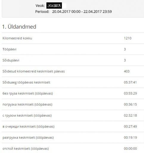
With regard to each status, the report contains a supplementary field in which the user can add additional relevant information. When information is added to the relevant fields identifying the client, the service provided or cargo delivered, the report becomes an operations journal and can be used as input data by an invoicing application. No entry will remain unnoticed, no penny wasted.
The operating status report can be exported for further processing into the customer’s business software. For further reading, see the article Transfers of Data between Systems
An ambulance service uses operating status data to analyze responses to emergency calls.
The ambulance service has defined the following operating statuses: waiting for an assignment, on its way to a patient, at the patient’s location, on its way to the hospital, in maintenance, in reserve.
The point of departure for the service is the time when an emergency call-out is received by the emergency services call centre. What needs to be done first is to measure the crew’s precise response time and the time it took to reach the destination. These will be reflected in operating status changes.
The process of responding to the call-out is subsequently scrutinized and operational performance is analyzed. The crews go through this routine on a constant basis, subjecting every delay to critical examination. This ensures better preparedness and a reduction of response times.
In addition, the dispatcher can also see the real-time operating status of the ambulance crew, indicated by the colour of the dot representing them on the map.
It is in the interest company of the fuel hauling to have its tankers offload the fuel at the petrol stations as quickly as possible.
It is equally important to be able to easily verify the location and time of offloading. This does not require a keyboard – signal leads connected to the controller’s inputs will show when the offloading pump is switched on and when the trailer’s side hatch is opened. With a mouse click on the relevant line in the report, the logistics dispatcher can easily verify whether the offloading pump’s operational cycle (i.e., the offloading site) corresponds to the customer’s location.
Reports concerning the status changes of the offloading pump and the trailer’s side hatches are automatically sent to the company’s business software which compares them to the offloading time assigned by the Customer Orders / Sales module. As a result, any offloading operations that exceed the assigned time-limit are highlighted. Faster offloading reduces the tankers’ stationary time which in its turn translates into better hauling performance – which means increased profits for the company and better pay for the driver.
For a timber hauling company, it is of crucial importance to maximize the number of customers served during a business day.
In addition to the time spent on road, it is important to know the time that it takes to load and offload cargo by means of the truck’s loading crane and what proportion of the total time spent at the site is taken up by the loading/offloading operation. In order to measure the duration of the work performed while the vehicle is stationary, the device is wired to receive signals from the hydraulic pump and the crane. The device consistently records changes in the operating status of both mechanisms. The report reveals the periods during which the hydraulic pump operates without a load, suffering needless wear and tear. If it appears to take too much time according to the report, the particular operation will be scrutinized separately and, if necessary, adjustments will be made to the work process to reduce the loading/offloading time and improve the general efficiency of the service. The map data linked with the operating status allows dispatchers to check whether or not the offloading occurred at the right address and/or at the time agreed with the customer.
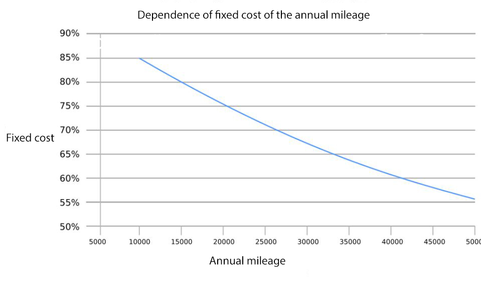
How and to what extent can the shared use of vehicles reduce your company’s costs? The less a vehicle is used, the more it’s going to cost you. Although this sounds paradoxical, the stark reality of the matter is that stationary vehicles generate no profit! A leased car which travels 10,000 km annually costs the company 6,700 euros. Of that amount, 85% constitutes fixed cost and does not depend on the mileage travelled.
| Annual mileage (km) | 50000 | 40000 | 30000 | 20000 | 15000 | 10000 |
| Mileage-related costs | ||||||
| Petrol (6l/100km, 1.05€ / l) | 3150 | 2520 | 1890 | 1260 | 945 | 630 |
| Maintenance (300€ per visit) | 1000 | 800 | 600 | 400 | 300 | 300 |
| Tyres (400€, 50000km per set) | 400 | 320 | 240 | 160 | 120 | 80 |
| Fixed cost | ||||||
| Tyre change (40€ per one change) | 80 | 80 | 80 | 80 | 80 | 80 |
| 3-party liability insurance (11€ per month) | 132 | 132 | 132 | 132 | 132 | 132 |
| Comprehensive insurance (35€ per month) | 420 | 420 | 420 | 420 | 420 | 420 |
| Car wash (35€ per month) | 420 | 420 | 420 | 420 | 420 | 420 |
| Parking (12€ per months) | 144 | 144 | 144 | 144 | 144 | 144 |
| Fringe benefit (75€ per month) | 900 | 900 | 900 | 900 | 900 | 900 |
| Operational leasing (300€ per month) | 3600 | 3600 | 3600 | 3600 | 3600 | 3600 |
| Total annual expenditure on the vehicle | 10246 | 9336 | 8426 | 7516 | 7061 | 6706 |
| Including fixed cost | 5696 | 5696 | 5696 | 5696 | 5696 | 5696 |
| Percentage of fixed cost in total expenditure | 55.6% | 61.0% | 67.6% | 75.8% | 80.7% | 84.9% |
Less kilometres travelled implies a greater share of fixed costs in the total cost of the vehicle. A quick glance at the expense figures prompts the question: does the company really need each and every vehicle it owns? Surely everyone is interested in cutting down on expenses if this can be done without compromising the quality of the company’s products or services…
By counting the number of journeys in a day, accounting the vehicles’ moving and stationary time and considering the geography of in-motion and stationary positions, you can assess the efficiency of use of the vehicle. A good way to increase that efficiency is to share out any underused vehicles. In fact, it may turn out that the company’s every fifth or even fourth vehicle is redundant. Each eliminated vehicle means 6000+ € in savings. A significant sum, surely enough to inspire a minor effort on your part, right?
The shared use of vehicles is unthinkable without a reservation system – which is one of the standard modules of Metrotec’s GPS tracking solution.
• Installation of tracking devices
• Monthly subscription fee for use of the web application and mobile communications
• Purchase price of tracking devices
• Tracking device rental fees

Regardless of whether you opt for renting or purchase of you device, its installation always entails additional expense. If this is not listed separately in the case of rent, the rental agreement or the general terms and conditions of the service should be read carefully. Whether you should opt for purchasing or renting the tracking device will be discussed below. Let us first take a look at the price components separately.
Probably the simplest answer is that the installation fee is proportional to the complexity of the job. If the client only requires location tracking, the installation will be completed at the most within an hour and the lowest rate will be charged. Here, the technician needs to find a suitable place for the tracking device and the antennae, connect the device to a mains and wire in the ignition.
The complexity of the installation increases when fuel consumption needs to be measured. Depending on the client’s wishes and the type of the vehicle, several options can be considered here.
In passenger cars and commercial vans, fuel data can be conveniently obtained from the CAN bus. The installation of a CAN connection takes approximately 1.5 hours. In addition to fuel level, information provided by the CAN bus includes engine RPM and other useful parameters. In different vehicle types, connection points are located in different spots, which requires the technician to have the necessary preliminary knowledge.
Although in trucks, too, fuel consumption readings are often obtained from the CAN bus, much more accurate measurements can be made using autonomous fuel level sensors. Connecting fuel level sensors to a tracking device has become a popular solution that is widely used in heavy goods vehicles, construction equipment, quarry equipment, agricultural machinery and other special-purpose vehicles, including locomotives.
The installation of a fuel level sensor means mounting the sensor unit inside the fuel tank, running a cable from the sensor to the device, making the necessary connections and calibrating the sensor. On the average, this can accomplished within 3, 4 or 5 hours, depending on whether the vehicle has 1, 2 or 3 fuel tanks. However, installation procedure may sometimes require extra time and involve extra cost due to unforeseen circumstances such as the need to remove various covers or even to dismount the fuel tank itself.
Clients often have additional requirements, such as the installation of a driver identification system, alarm or extra sensor, or the creation of a monitoring solution for various on-board systems (crane, parking heater, etc.). In these cases, we will provide a separate quote regarding the additional work required.
The upshot is that the cost of installation is determined by the time it requires and depends on the number and complexity of the nodes to be installed. It is always listed as a separate item in our price quotes.
The price of our hardware packages depends entirely on what the client needs. The primary factor is the desired functionality of the controller unit or its intended purpose of use. By price, our hardware can be grouped as follows:
Considering that the device packages may additionally include different switches and sensors, thermometres, engine RPM detectors, RFID readers, keyboards for changing the vehicle’s operational status, etc., the number of possible combinations becomes rather large.
The most important item in the device package is the controller. Controllers differ from each other in terms of their features, capacity and price. Even the most powerful unit that can manage a large number of connections may be used for positioning only, although it is certainly impractical.
Even when you are seeking the least expensive option, it will be prudent to spend a minute or two to consider the likelihood of any future need to, say, measure the engine RPM or exploit other useful features of our systems. It is important to bear in mind that your choice of controller may considerably limit your future options, since our controllers are designed to support varying ranges of features.
As you can see from the above, tracking solutions can have a wide variety of configurations. For this reason, we advise customers to take a broader look at their present and future needs before asking for a quote.
To sum it up briefly, for the monthly service fee the client will be provided an exemplary service complete with technical support and continuous development of the system. The monthly fee also includes the cost of a GSM SIM card.
Important keywords here include the following:
The monthly service fee depends on the range of software modules activated for the client’s use. In addition to location tracking and fuel consumption monitoring – the two staple choices – we offer reservation, routing, two-way communication with drivers, remote downloading of tachograph data, data integration, communication of work orders, driver identification, etc. A large number of active modules implies extensive use of the system’s functionality by the client, which in its turn requires the round-the-clock availability of corresponding technical and analytical support.
The monthly service fee includes a charge for the GSM SIM card. Different rates will apply depending on the region where the vehicles operate (in Estonia, EU countries, non-EU countries). Customers don’t have to worry about the SIM cards, we will pre-install them and make the necessary service arrangements.
It is always possible to rent tracking devices either for a fixed or unspecified term.
If you are considering device rental, please read carefully the rental agreement, especially the terms of its termination, and the general terms and conditions of the service.
Rental fees reflect the capacity and value of devices, as do prices at which devices are available for purchase. Rental fees do not include the cost of installation.
The service provider has made an investment to offer rental devices. Their cost recovery period is determined by the company internally. Typically, the period is set at 1.5 to 2 years. At the end of the period, the client’s regular rental payments to the service provider will have covered the manufacturing cost of the device and a certain markup. The device itself, however, will always remain the property of the service provider.
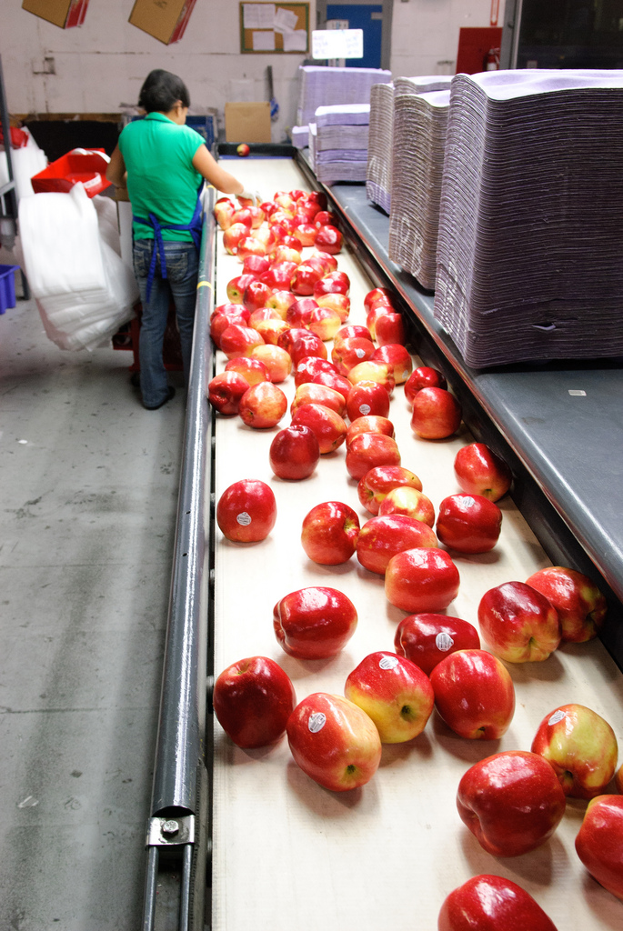 This is handled by Webservice which is a piece of software intended to link up different applications or systems. Webservice comes into play when data gathered by different applications need to be exchanged or when data gathered by one application need to be transferred to another for further post-processing. One could compare this to a conveyor belt that makes a product partly processed by one production node automatically available to the next node.
One of the many benefits offered by GPS tracking solutions is their application to the identification of drivers and to the gathering of data on how drivers operate their vehicles. Your tracking solution can be equipped with a peripheral to record drivers’ arrival to and departure from work in the vehicle.
In most companies, employee working hours are being kept track of by an accounting application. This means that the arrival to and departure from work events registered by the GPS tracking solution must be transferred into that application.
To do this by hand – by displaying the data on the daily work cycles of the drivers in one window and manually entering them in the other system’s window – is very tedious and prone to error. A less laborious process with a diminished risk of errors is to save period data as a separate file that will then be transferred to the accounting application. Yet this too is a tiresome procedure that an employee has to perform physically and that runs counter to the automatic synchronization intuitively expected of contemporary systems.
This lack of synchronization will sooner or later inevitably lead to a situation where, due to missing or incomplete data, errors are made in the calculations, decisions are based on incorrect assumptions, a misunderstanding arises or, in the worst case, everything descends into chaos. To rule out these risks, all routine and tedious procedures should be performed by software and automated to the greatest possible extent.
Web service (an application interface, or API) allows other systems to automatically access various GPS-generated data.
Different companies have their own order management systems which register all stages that a product or service sold to a customer goes through. These stages may include specific delivery actions from point A to point B. Such delivery actions in their turn can easily be fed into the GPS tracking system which, among other features, offers the option of transmitting destinations and work orders to the navigation units used by drivers.
In this case, Web service allows the system to automatically transmit an order entered by a salesperson in the order management system to the person who will perform the order – with minimum delay and conversion, ensuring accuracy and speed.
Destinations and work orders can be fed into the GPS tracking system from external sources. It is possible to effect the switching of specified control circuits (engine shutdown, immobilizer activation, central locking system, etc.) connected to the unit.
The customer should identify their requirements and turn to Sales Representative for support, who can then provide API description and additional explanations.
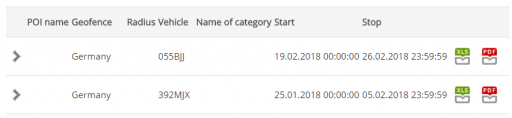
The user can define specific areas on the map and learn, from the corresponding geofence reports, when its vehicles entered and left those areas and how long they stayed there.
An international hauling company needs to know how much time its vehicles have spent in Germany. Why? The EU’s regulations require drivers to be paid the German minimum wage for the time spent in Germany. Similar rules are about to enter into force in France and Austria. Countries that have higher salaries use such measures to protect their domestic market from being invaded by East European hauling companies. The hauling company must produce proof that the driver’s salary has been calculated as required. A geofence report can generate such proof in less than half a minute.
An oil shale enrichment plant separates the ore from the gangue. The ore goes onto a conveyor belt and the gangue into a bunker from where it is loaded on dumpers and hauled back to the tailings stack. The mining company pays the hauling company by volume of gangue transported and by vehicle mileage. For its part, the hauling company needs to be able to check whether the calculations of the mining company are correct. Since the volume of the dumper’s load is known, it remains to count the trips made from the bunker to various destinations. To receive this information, the hauling company defines a set of geofences on the map.
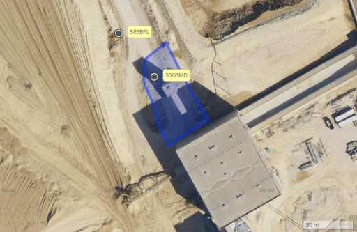
The reports created with respect to the period defined by the hauling company provide the precise number of visits by each truck, as well as the time and duration of loading.
A property maintenance company is hired to clear snow from various business premises. The agreements stipulate an hourly rate for the service, which must be performed without notification whenever a snow cover is present. It would be highly cumbersome for the company to manually record the entry and exit times and hours worked on the various premises.
The snow clearing operator creates geofences along the boundaries of the premises to be cleared. This will do away with tedious and time-consuming paperwork and timesheets. Precise billing data are generated in less than half a minute and the geofence report provides a record of the hours worked on each customer’s premises.
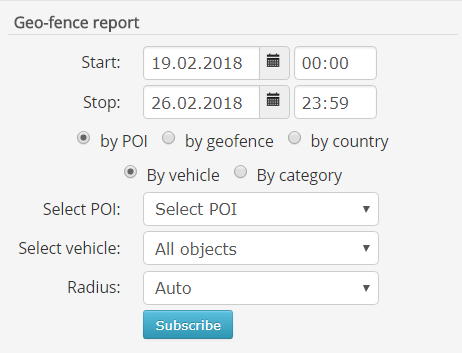
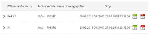
The serviced locations of a client can also be marked on the map as points of interest (POI). When the POI is assigned a radius, the software regards it as a geofence with the corresponding circumference. As a result, the system generates a geofence report that states precise service duration at the location, as well as the times of arrival and departure.
Navigation before GPS was not only possible but also reliable
Modern GPS navigation has been in use but a couple of decades, yet the art of locating one’s position has a history that long predates the advent of the satellites. Nowadays, even among professional mariners, there are those that no longer understand how to navigate without modern instruments. However, even in this age of GPS-capable smartphones and navigation devices, it may come in handy to remember what to do if you are unable to obtain a signal from the sky or the battery of your pocket device has died.
Lighthouses and maps have already been in existence for hundreds if not thousands of years. Wayfarers took their bearings by the lay of the stars in the night sky and ancient mariners kept their vessels within sight of shore avoiding the high seas. Light boats were enough to settle the Pacific Ocean islands which are sufficiently close to each other and blessed with an abundance of clear night skies over the surrounding ocean waters.
Thousands of years ago, the early sailing vessels would cross the South China Sea and the Indian Ocean by taking advantage of monsoon winds which always blow in the same direction as long as the season lasts. These favourable winds made it possible to cross the open seas twice a year without fear of getting lost. At the same time, the Icelanders living far up north used the light-polarizing property of a special rock (the sunstone) the surface of which when polished smooth revealed the position of the sun even under a clouded sky, a weather condition relatively common on the northern seas. The position of the sun also allowed approximate estimation of direction and location.
Compass – a relatively recent invention
The compass, which to our modern age seems an incredibly simple tool, was invented in China relatively recently – a few hundred years before Christ – and was introduced in Europe by Persians only in the 13th century. The magnetized needle of a magnet compass is mounted on a pivot point which allows the needle to turn freely and align itself with the Earth’s magnetic field which determines the needle’s north-south orientation. Compasses and cartography considerably facilitated sea travel and exploration of wilderness ―maps gained in accuracy and even the Estonian coastline assumed a recognizable shape on medieval sketches.
The North Star―how can it help you find your bearings?
An ancient and reliable method to find one’s bearings in the wild when no compass is available is by reference to the North Star. This bright star that shines in the night skies of the northern hemisphere appears to sit above the Earth’s north celestial pole throughout the year and allows to determine the direction of true north. Once we have located that star, we can also determine the latitude of our position—the altitude at which the North Star is observed above the horizon roughly corresponds to the latitude of the observer.
A long exposure star trail photo reveals that everything rotates around the North Star. This direction is the true north and the altitude between the star and the horizon equals the latitude of the observer. Photo: (CC) Kevin Hadley / Wikipedia
Precise determination of one’s longitude and latitude also requires the exact measurement of time, performed until the 16th century by hourglass or clepsydra (a water clock). Finally, in the 1760s, a marine chronometer was created which could work reliably on a rolling and pitching vessel and allowed the determination of geographical position in any weather.
The sextant – high-precision angle-measuring navigation instrument
The sextant only became part of the navigation equipment in 1757. It is still used as a back-up when there is a power outage out or when electronics fail. It allows to measure – with considerable precision — the angle between a celestial body and the visible horizon and, based on that measurement and the exact time that it was made, to calculate one’s latitude. In clear nights, it is possible to use the North Star to find one’s directions and to determine one’s latitude.
The sextant is essentially an optical instrument that, by means of mirrors, allows to combine the images of two objects in a single visual field. The position of the mirrors is adjusted with the help of an adjusting worm such that the position of the celestial object observed is projected to the horizon in the sighting tube. The numerical value of the angle measured is then read from the drum of the adjusting worm. As this description shows, measuring the angle is a rather straightforward procedure. It is the calculations involving time that present more difficulty.
Radio waves guiding the way
In 1906 for the first time a seafaring vessel was fitted with a device which, by mechanical rotation, could accurately determine the direction of a radio signal. Thus, the first radio beacons appeared, capable of reaching ships yet behind the horizon and of guiding them to port.
In 1930s, the first automotive navigation systems appeared. Yet, these were not the high-tech wonders we are accustomed to nowadays – their first appearance was in the form of simple map rollers mounted on the car’s dashboard where they could be turned by the front seat passenger to reveal the directions to the next waypoint.
World War II spurred the development of the early long-range radio navigation system LORAN whose four stations provided guidance to the ships on the east coast of the United States and Canada.
The first communications satellites launched already a few years after Sputnik
The age of satellites may be said to have begun in 1957 when Sputnik 1, the world’s first artificial satellite, was launched into the Earth’s orbit by the Soviet Union. It then took until 1962 for a solution that resembles GPS navigation to emerge: although doing it very roughly, the seven satellites of the TRANSIT system facilitated the determining of ground locations. Compared to the compass and sextant, the new system was faster and more reliable.
From this point on, the accuracy of satellite navigation has improved continuously. On 1 May 2000, by decision of the US military, the accuracy of civilian GPS receivers was upgraded from several hundred to several metres. Today, we can already enjoy the accuracy of one metre in our GPS-capable smartphone or smartwatch, or a separate navigation device. This is usually quite enough for finding your way or the desired location.
While the accuracy of the GPS receivers was upgraded to the level permitting street navigation only in 2000, first attempts at automotive navigation go back a century. The task was accomplished at first by mechanical gadgets and later by electronic devices.
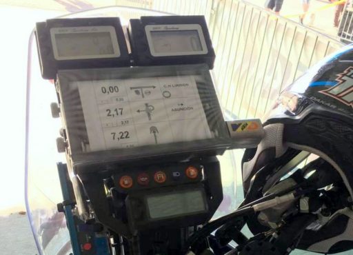 At the 2017 Dakar Rally, taking place from 2 January to 14 January, the Estonian bikers used simple and reliable map rollers that were first employed more than a century ago. With all the noise and dust that bikers are exposed to, these can sometimes be of more use than contemporary electronic navigators. The roadbook, describing the turns ahead along the track, can also be recorded on such rolls.
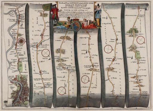
The very first automotive navigation systems were rather primitive map rollers that could be attached to the car’s dashboard and manually turned as the car advanced along the route.
Travellers had carried such map rollers in their pockets for quite a few centuries, yet they would only be employed in automobiles for the first time in the 1920s. Crafty precision mechanics crammed the rollers into a watch-sized case, to be worn on the wrist similarly to a normal timepiece.
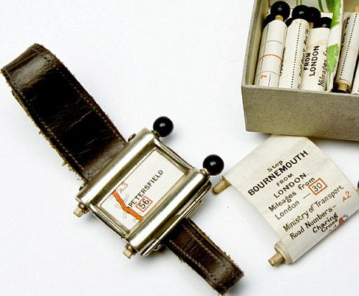 The navigation system called Plus Fours Routefinder consisted of a casing housing two wooden rollers which could be used to forward or rewind a roll of paper – not unlike the rolls of receipt printer paper that we are so familiar with – that bore a map showing the way from one of the popular starting points to a popular destination, to be purchased separately according to the journey envisaged. At a crossroads, one had to manually wind the map forward see which direction one needed to take to reach the next forking. The edge of the scroll also showed the mileage covered. Unfortunately, this invention never achieved wide popularity, receding into the ranks of 20th-century curiosities, and is now part of a collection of weird and wonderful inventions and gadgets on display at the British Library in London. Today we could say that this clever gadget was too advanced for the time, since automobiles in the 1920s were few and far between, which effectively precluded the gadget’s attaining popular appeal. What was also significant is that the selection of roads for which maps were available remained rather limited.
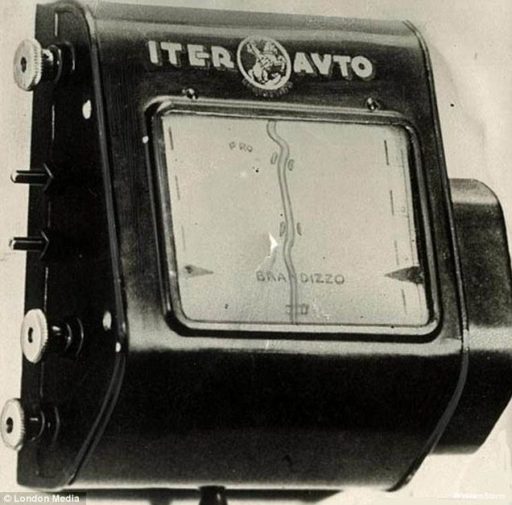 In the 1930s the number of cars rolling on the streets began to grow. This created an incentive to start designing navigation equipment available to motorists as an optional extra. One of the first of its kind was the Italian-produced Iter Avto―a voluminous box which was fixed onto the car’s dashboard moulding and featured a wide map display window. Externally, it already bore semblance to the first cumbersome contemporary navigation units, although its innards held a mechanical map system. Compared to Plus Fours Routefinder, it represented a step further―the motorist did not have to manually wind the map forward. Instead, the device was connected to the speedometer cable and would turn the map scroll according to the speed of the car, approximately matching the vehicle’s progress along the route. The expensive gadget showed intersections and ‘rotated’ the map to match the direction of the car. From time to time, the scrolling speed had to be adjusted, since a mechanical solution such as this could not provide the required precision.
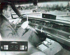 In 1960s, the General Motors Company decided to assist the motorists travelling long-distance on U.S. highways by manufacturing a device called DAIR (Driver Aid, Information & Routing). The device which read driving directions (where to turn, which traffic signs are ahead, where limited speed zones begin and how long the motorist must continue down the same road without turning) from punched cards also received radio transmissions to warn the driver of obstacles on the road and of accidents ahead.
At the end of the 1960s, the development of automotive navigation systems expanded beyond the automobile itself. Thus, Germany started testing so-called smart roads, sided by small radio beacons which transmitted additional information to devices installed in the car. The primary data transmitted by the beacons was location data, but they also provided current information on driving conditions and speed limits. Yet again, this system too proved too advanced for the time and non-tested roads would have to wait another 50 years to become smart.
It was finally in 1995 that Oldsmobile presented its Guidestar Navigation System which featured a GPS receiver and an electronic display. Initially the system’s accuracy was rather low, but it could still be useful on intercity roads. Satellite-guided automotive navigation systems was a prominent topic discussed in the television series Beyond 2000 which showcased future technologies, being as popular then as self-driving cars are now. Although, at the time, the hosts would concede that no matter how good the navigation equipment, it will not replace a good driver.
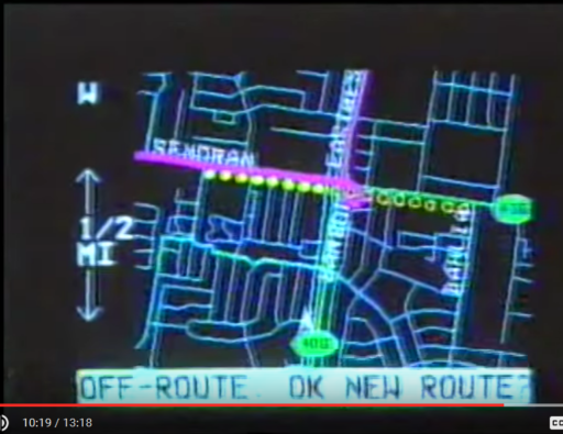
Video: https://youtu.be/NCGmxk3H44g?t=6m20s
(The section on automotive navigation begins at 6:20)


